Elk Lake
Key Facts
Overview
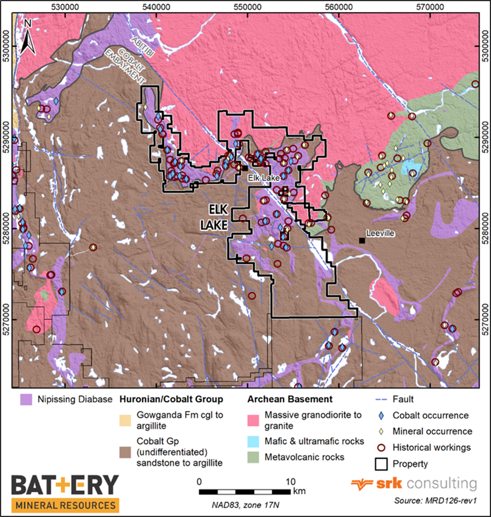
BMR is the largest landholder in the historic Elk Lake Silver-Cobalt Mining Camp. The Elk Lake project area is located about 111 kilometres (km) southeast of Timmins and 150km northeast of Sudbury, centred on the town of Elk Lake. The property is readily accessed via logging roads and ATV trails that exit north and south from Highway 560 and east and west from Highway 65. Mining in the Elk Lake area started in 1906 following the discovery of native silver in cobalt which gave rise to Elk Lake as a mining camp. Between 1907 and 1913, there were about thirty active properties in the area which aggregated a total production of approximately 110,000oz of silver and 3,155lbs of cobalt.
Between 2018 and 2021, BMR drilled four showings, many of them with historic workings and minor silver and cobalt production, amounting to 39 holes totaling 5524.19m.
- 2018-Roy - Sunvest JV former producer: 14 holes/ 2353.00m:
- 2020-Cotley former producer: 7 holes/ 1074.83m;
- 2020 Silverstrike prospect: 6 holes/ 690.00m;
- 2021 Mapes former producer: 12 holes/ 1406.36m.
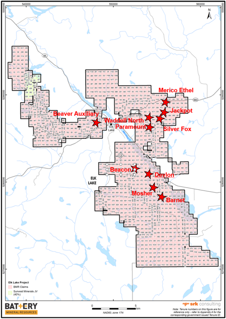
BMR has identified numerous historic workings for ground follow-up to identify additional drill targets including Silver Fox, Jackpot, Merico Ethel, Beaver Auxiliary, Devlin, Mosher, Barnet, and Beacon in the Elk Lake project area. BMR is targeting high-grade five element style vein mineralization.
BMR's Elk Lake exploration program highlights include:
2018 Roy-Sunvest JV former producer: Drilling: 14 holes/ 2353.00m;
- 0.53% cobalt over 1.15m from 25.91m including 3.61% cobalt, 15.3g/t silver and 0.78% copper over 0.14m from 26.42m (Drillhole ELR18001)
- 0.23% cobalt, 21.8g/t silver and 5.11% copper over 0.10m from 54.10m and 0.11% cobalt, 8.69g/t silver and 1.16% copper over 0.10m from 18.26m (Drillhole ELR18005)
- 0.85% cobalt, 7.67g/t silver and 0.27% copper over 0.45m from 21.00m (Drillhole ELR18012)
- 0.62% cobalt and 3.33g/t silver over 1.66m from 37.86m (Drillhole ELR18013)
- 0.44% cobalt, 2.45g/t silver and 0.06% copper over 0.23m from 29.85m (Drillhole ELR18014)
2020 Cotley former producer: Drilling: 7 holes/ 1074.83m;
- 109.20g/t silver over 2.0m from 145.9m (Drillhole ELC20004)
- 23.4g/t silver and 0.42% copper over 0.5m from 57.60m (Drillhole ELC20007)
- 18.45g/t silver over 4.0m from 40.5m (Drillhole ELC20006)
- 13.4g/t silver and 0.29% copper over 2.0m from 56.00m (Drillhole ELC20001)
- 4.74g/t silver over 13.0m from 32.0m (Drillhole ELC20005)
2018 Silverstrike Rock Grab Sampling;
- 1.70% cobalt and 10.30g/t silver (R0003)
- 1.22% cobalt and 8.57g/t silver (R0001)
- 0.69% cobalt and 8.23g/t silver (R0005)
- 0.59% cobalt and 9.63g/t silver (R0002)
- 1.42% cobalt and 23.6g/t silver (R0006)
2020 Silverstrike prospect: Drilling: 6 holes/ 690.00m;
- 0.22% cobalt and 4.62g/silver over 0.70m from 58.75m (Drillhole ELS20003)
- 0.18% cobalt over 1.25m from 24.75m (Drillhole ELS20004)
- 0.03% cobalt and 1.80% copper over 0.60m from36.20m (Drillhole ELS20005)
2021 Mapes Rock Grab Sampling;
- 1.89% cobalt, 30.80g/t silver, 0.98% copper and 0.21% nickel (R0181)
- 5.06% cobalt, 97.00g/t silver, 2.52% copper and 0.43% nickel (R0182)
- 2.44% cobalt, 631.00g/t silver,1.43% copper and 0.11% nickel (R0183)
- 0.85% cobalt. 46.80g/t silver, 0.14% copper and 0.07% nickel (R0193)
2021 Mapes former producer: Drilling: 12 holes / 1406.36m;
- 0.63% cobalt, 7.52g/t silver and 2.24% copper over 1.00m from 59.00m (Drillhole ELM21005)
- 0.25% cobalt, 1.29g/t silver, 0.14% copper and 0.68g/t gold over 0.50m from 6.40m (Drillhole ELM21007)
- 0.37% cobalt, 4.11g/t silver and 0.10% copper over 0.75m from 104.25m (Drillhole ELM21008)
- 0.62% cobalt, 14.55g/t silver and 0.13% copper over 0.50m from 64.25m (Drillhole ELM21009)
ELK LAKE PROPERTY RECONNAISSANCE TARGETS (BMR 100%):
Rock grab sampling of the following Elk Lake targets produced several significant rock grab assay results:
- Silver Fox: 0.40% cobalt, 8.34g/t silver and 0.54% copper (R1159)
- Jackpot: 0.23% cobalt, 155.00g/t silver and 6.47% copper (R1165)
- Waddell North: 0.93% cobalt, 14.70g/t silver and 4.60% copper (R1191)
- Paramount: 0.72% cobalt, 29.60g/t silver and 0.17% copper (R1200)
- Merico Ethel: 0.84% cobalt, 5.41g/t silver and 9.86% copper (R1147)
- Beaver Auxiliary: 0.28% cobalt, 85.70g/t silver and 1.44% copper (R2203)
Historical Background
The Elk Lake area is host to numerous former mines, abandoned workings, and prospects. Mining efforts began shortly after the discovery of native silver in 1906, giving rise to Elk Lake as a mining camp. Mining peaked between 1907 and 1913, when there were about thirty active mining properties in the area.
As BMR controls the largest claim block in the Elk Lake Silver district, a complete review of all historical work undertaken in the BMR claim block is not feasible; many companies have operated in the district over the last 110 years, and therefore, the Elk Lake area is host to numerous former mines, abandoned workings, and prospects.
Geology & Mineralization
The outline of the Elk Lake property follows that of a large conical or basin shaped body of Nipissing diabase that defines a sigmoidal map pattern. It intrudes Proterozoic Huronian Cobalt Group sedimentary rocks typical of the Cobalt Embayment near—and at— its lower unconformable contact with the Archean basement.
Surface mapping and drill holes which have penetrated the unconformity, reveal that granitoid phases of the Round Lake Batholith underlie the entire Elk Lake area.
Mineralization generally occurs in the diabase, often in the upper portion (as at Gowganda) but may occur in the Huronian sedimentary rocks or at the contact with the Archean basement rocks. The area is best known for high-grade silver, with accessory cobalt and nickel.
Mineralized silver-cobalt veins are strongly focused within well-developed structures. Mineralization is dominated by narrow copper-iron-silver-cobalt +/- gold) rich calcite-quartz veins and cobalt-nickel rich calcitic veins that run parallel to dominant faulting, fracturing or jointing, often following partially around cylindroidal joints, but appear to be uniquely oriented at each location.
Current Exploration
Most of the historical mining related features are documented by the Ministry of Energy Northern Development and Mines (MENDM) in their Abandoned Mine Information System (AMIS) as sites and features on OGS-Earth satellite imagery. Many of these known features, as well as numerous undocumented shafts, pits and trenches, are readily discernable on LIDAR maps of the Elk Lake area. Using AMIS, LIDAR, Kirkland Lake Resident Geologist’s files and OGS reports, numerous old workings were identified and visited, including;
- Cotley,
- Silver Shield
- Cameron
- Otisse
- North American
- Mapes
- Silverclaim Lake
- Ethel, Merico
- Silver Fox
- Jackpot
- Other unidentified sites
Follow up work included ground truthing prospecting traverses, sampling of pits, trenches and waste piles, and diamond drilling as detailed below:
ROY SUNVEST JV SAMPLING AND DIAMOND DRILLING
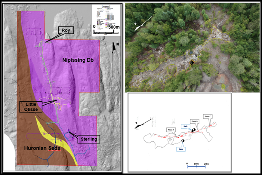
At Roy, most of the historic work was conducted on three former prospects that were explored underground via adits and shafts. From north to south the prospects include the Roy, Little Otisse and Sterling.
Historic production at Roy in 1954, was reported as 2,472 tons of treated ore that produced a carload of cobalt-copper concentrate averaging 7% cobalt and 6% copper.
Under private ownership, the Roy property produced 1084oz, and 804oz of silver in 1964 and 1966, respectively. Between 1996 and 2006, several outcrops on the Roy property were stripped and sampled.
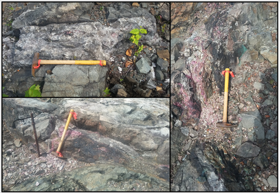
Grab samples of the vein collected by OGS District Geologist near the shaft and to the south, assayed up to 1.96% cobalt, 233g/t silver, 13.6% copper and 0.15% nickel.
The Roy prospect - Sunvest JV diamond drilling program comprised 14 holes/ 2353.00m. The holes targeted the strike extensions of the main vein at Roy, the Little Otisse and Sterling workings as well as geophysical IP anomalies.
Significant assays from the drilling include:
- 0.53% cobalt over 1.15m from 25.91m including 3.61% cobalt, 15.3g/t silver and 0.78% copper over 0.14m from 26.42m (Drillhole ELR18001)
- 0.23% cobalt, 21.8g/t silver and 5.11% copper over 0.10m from 54.10m and 0.11% cobalt, 8.69g/t silver and 1.16% copper over 0.10m from 18.26m (Drillhole ELR18005)
- 0.85% cobalt, 7.67g/t silver and 0.27% copper over 0.45m from 21.00m (Drillhole ELR18012)
- 0.62% cobalt and 3.33g/t silver over 1.66m from 37.86m (Drillhole ELR18013)
- 0.44% cobalt, 2.45g/t silver and 0.06% copper over 0.23m from 29.85m (Drillhole ELR18014)
Hole ELR18013 was a vertical hole intended to drill through the stratigraphic package into the basement. It exited the diabase into Huronian sediments at 148.21m and subsequently entered the basement granitic complex at 177.40m.
COTLEY PROSPECT (BMR 100%)
The Cotley mine was the largest historic producer in the Elk Lake camp. Government records indicate a 290-ton underground sample from the Cotley Mine taken in 1953, yielded historic production of 63,471oz silver and 1,214 pounds of cobalt.
Recent exploration includes drilling in the summer of 2007 by Amador Gold when 19 short holes (1398m) were completed around the Cotley shaft area in the search for silver.
Eight of the holes encountered veins yielding anomalous values between 0.1% and 0.3% cobalt with a few spikes over 1.2% cobalt, all over narrow widths and associated with anomalous to high silver values. The drilling intersected numerous high-grade silver intercepts over wide downhole intervals including:
- 332.81g/t silver over 4.24m from 23.86m (Drillhole AGSC0715)
- 267.70g/t silver over 6.35m from 19.71m (Drillhole AGSC0720)
- 200.15g/t silver over 3.31m from 39.44m (Drillhole AGSC0710)
- 192.46g/t silver over 6.99m from 26.00m (Drillhole AGSC0712)
- 152.39g/t silver over 10.29m from 29.01m (Drillhole AGSC0707)
- 95.74g/t silver over 7.81m from 23.88m (Drillhole AGSC0706)
- 80.42g/t silver over 11.01m from 28.60m (Drillhole AGSC0721)
- 68.75g/t silver over 8.62m from 23.91m (Drillhole AGSC0718)
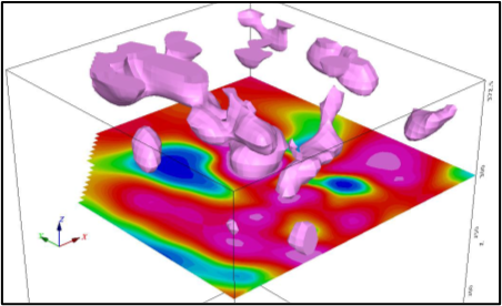
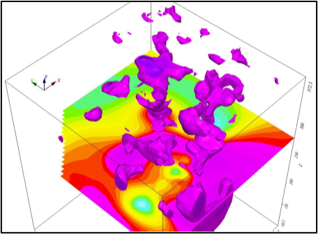
BMR ‘s exploration at Cotley commenced with prospecting, rock sampling and detailed geological mapping around the historic workings followed by grid-based and downhole geophysical three-dimensional distributed induced polarization (“3D IP”) surveys.
The initial 3D IP grid-based survey targeted the largely unexplored southwestern section of a Nipissing diabase sill which hosts many of the historic Elk Lake area mines including the former Cameron - Cotley minesite.
A follow-up borehole BH3DIP survey was completed to better delineate the grid-based survey chargeability anomalies. The survey utilized 3 historic Amador Gold holes which highlighted and further defined numerous chargeability and low resistivity anomalies striking at 0-5 and 80 degrees. These anomalies appear to coincide with known mineralization and historic work. A total of 5944 filtered data points were collected from the three boreholes and inverted.
This survey confirmed that both mineralized vein systems are associated with high chargeability IP responses that are open along strike.
BMR’s drill program at Cotley targeted known vein zones and associated IP chargeability anomalies. This limited test confirmed that the known Silver-Cobalt veins are open along strike and at depth. This initial drilling comprised 7 holes totalling 1,074m.
Significant downhole silver assays with anomalous cobalt and/or copper values were returned in the drilling as follows:
- 109.20g/t silver over 2.0m from 145.9m (Drillhole ELC20004)
- 23.4g/t silver and 0.42% copper over 0.5m from 57.60m (Drillhole ELC20007)
- 18.45g/t silver over 4.0m from 40.5m (Drillhole ELC20006)
- 13.4g/t silver and 0.29% copper over 2.0m from 56.00m (Drillhole ELC20001)
- 4.74g/t silver over 13.0m from 32.0m (Drillhole ELC20005)
The distribution of historic and current anomalous silver values confirms that there are two main mineralizing trends that coincide with the Main and Downey veins, but there are also possible branching and/ or cross-cutting vein sets.
The silver zones on both the Main and Downey veins are open along strike to the north and south and to depth.
Planning for follow-up drilling is underway.
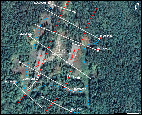
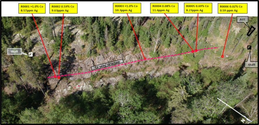
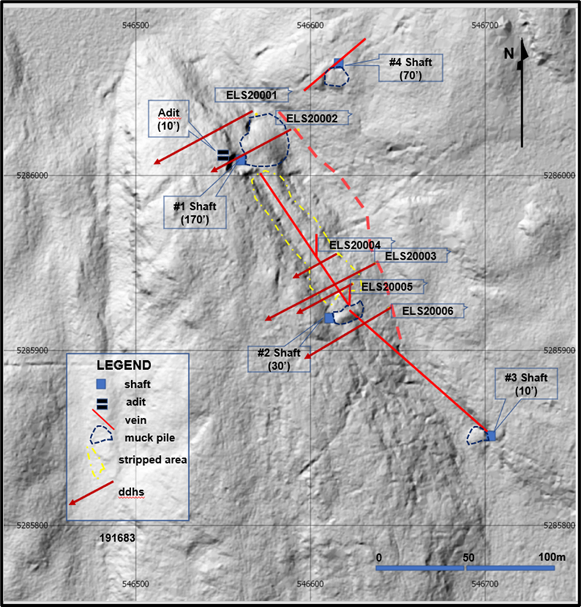
SILVERSTRIKE PROSPECT (BMR 100%)
The historic Silverstrike property is an agglomeration of several groups centred on the original discovery of a high- grade silver vein by prospector L. Downey in 1907. Two shafts were sunk at either end of the main vein zone while two additional shafts were sunk on a subparallel structure to the west and a crosscutting specularite- chalcopyrite vein to the northeast, respectively.
Prospecting of the Silverstrike area was undertaken by BMR in 2018. A total of 6 rock samples were taken from the main vein zone which is exposed over 100m between the number 1 and 2 shafts in the stripped area. These samples returned:
- 1.70% cobalt and 10.30g/t silver (R0003)
- 1.22% cobalt and 8.57g/t silver (R0001)
- 0.69% cobalt and 8.23g/t silver (R0005)
- 0.59% cobalt and 9.63g/t silver (R0002)
A grab sample of 30cm calcite vein material and Cobalt bloom from the waste rock pile of number 2 shaft yielded:
- 1.42% cobalt and 23.6g/t silver (R0006)
BMR’s August 2020 drilling was designed to determine the possible depth and lateral continuity of the mineralized fracture system between, and along strike of, the 2 shafts. Overall, 6 holes were drilled aggregating 690m. Significant intercepts are as follow:
- 0.22% cobalt and 4.62g/t silver over 0.70m from 58.75m (Drillhole ELS20003)
- 0.18% cobalt over 1.25m from 24.75m (Drillhole ELS20004)
- 0.03% cobalt and 1.80% copper over 0.60m from 36.20m (Drillhole ELS20005)
Two of the holes, ELK20001 and 003 were drilled through the base of the diabase sill into the Huronian sediments and intersected the Round Lake Batholith granitoid rocks at 147.42m and 145.2m, respectively. Thus, the combined diabase and sedimentary package at Silverstrike comprises a vertical thickness of approximately 100m.
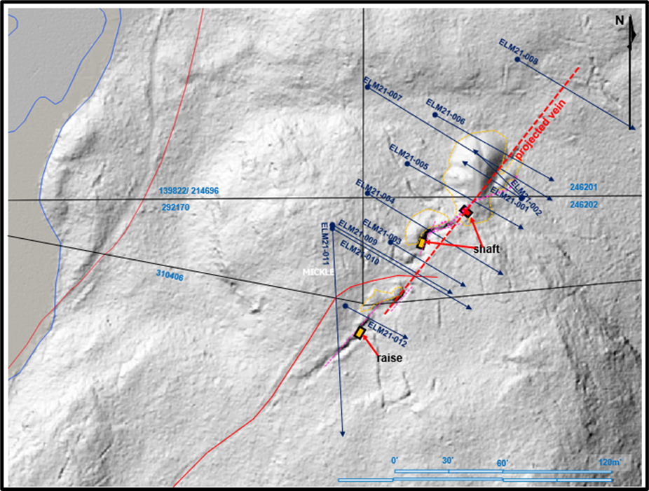
MAPES PROSPECT (BMR 100%)
Historical records indicate that the Mapes shaft (and winze) were sunk to a total depth of 115m with 320m of underground level development and 69m of raising; most of the work was completed before 1914 by Mapes- Johnston, and the remainder, by Alsof in 1963.
Coniagas Mine smelter/ mill records indicate that a 1915 shipment of 1.0-ton returned values of 1,328g/t silver, 11.00% cobalt and 8.00% nickel and, a further 1.5-ton sample yielded 12,719g/t silver, 9% cobalt and 9.00% nickel. Total reported production is about 1000oz silver and 870 lb. of cobalt.
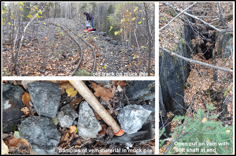
The Mapes-Johnston (“Mapes”) property hosts extensive surface workings and large muck piles that contained abundant vein material mineralized with cobalt bloom.
BMR rock grab sampling focused on the historic mine workings at Mapes returned significant cobalt and silver assays as follows:
- 1.89% cobalt, 30.80g/t silver, 0.98% copper and 0.21% nickel (R0181)
- 5.06% cobalt, 97.00g/t silver, 2.52% copper and 0.43% nickel (R0182)
- 2.44% cobalt, 631.00g/t silver,1.43% copper and 0.11% nickel (R0183)
- 0.85% cobalt. 46.80g/t silver, 0.14% copper and 0.07% nickel (R0193)
In 2020, a diamond drill program was undertaken to determine the continuity, and the on- strike and depth extents of the Mapes vein system. Significant downhole core intercepts include:
- 0.63% cobalt, 7.52g/t silver and 2.24% copper over 1.00m from 59.00m (Drillhole ELM21005)
- 0.25% cobalt, 1.29g/t silver, 0.14% copper and 0.68g/t gold over 0.50m from 6.40m (Drillhole ELM21007)
- 0.37% cobalt, 4.11g/t silver and 0.10% copper over 0.75m from 104.25m (Drillhole ELM21008)
- 0.62% cobalt, 14.55g/t silver and 0.13% copper over 0.50m from 64.25m (Drillhole ELM21009)
Veining intercepted in the drilling consisted of the calcite - quartz (+/- silver and/or cobalt) and specularite - chalcopyrite veins which often carried anomalous (up to 0.68g/t gold) values.
ELK LAKE PROPERTY RECONNAISSANCE TARGETS (BMR 100%)
BMR field crews conducted reconnaissance traverses targeting prospects that had been identified from Ontario government reports and assessment file data supplemented with LIDAR data which was used to pinpoint the location of specific features. Old shafts, pits, outcrops and their waste rock piles were examined and sampled to evaluate each site for potential follow-up.
These field-based prospect assessments involved prospecting and detailed geological mapping to confirm the geological setting and structural controls as well as selected rock grab sampling.
Sampling of the following Elk Lake project sites produced several significant rock grab assay results:
- Silver Fox: 0.40% cobalt, 8.34g/t silver and 0.54% copper (R1159)
- Jackpot: 0.23% cobalt, 155.00g/t silver and 6.47% copper (R1165)
- Waddell North: 0.93% cobalt, 14.70g/t silver and 4.60% copper (R1191)
- Paramount: 0.72% cobalt, 29.60g/t silver and 0.17% copper (R1200)
- Merico Ethel: 0.84% cobalt, 5.41g/t silver and 9.86% copper (R1147)
- Beaver Auxiliary: 0.28% cobalt, 85.70g/t silver and 1.44% copper (R2203)
Target generation and field evaluations are ongoing in the Elk Lake area with numerous sites identified for field follow-up.
Anomalous gold values associated with the Specularite- Chalcopyrite veins were detected in the samples taken at the Jackpot and Jackpot South sites which returned 3.37g/t and 27.70g/t gold, respectively, Silver Fox West (19.75g/t gold), and, at Merico- Ethel (4.61g/t and 4.99g/t gold).
BMR crews recently completed site visits to the Devlin, Mosher, Barnet, and Beacon prospects. Rock sampling results are pending.
Technical Report
February 5, 2021: Technical Report on Cobalt Exploration Assets in Canada prepared for Battery Mineral Resource Corp. prepared by SRK Consulting (Canada) Inc.